


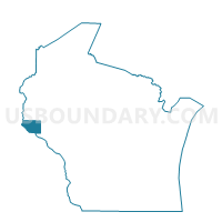
Prescott - C 2 Voting District, Pierce County, Wisconsin
About
Outline

Summary
| Unique Area Identifier | 696129 |
| Name | Prescott - C 2 Voting District |
| County | Pierce County |
| State | Wisconsin |
| Area (square miles) | 0.70 |
| Land Area (square miles) | 0.52 |
| Water Area (square miles) | 0.18 |
| % of Land Area | 74.17 |
| % of Water Area | 25.83 |
| Latitude of the Internal Point | 44.74499920 |
| Longtitude of the Internal Point | -92.79266120 |
Maps

Graphs
Select a template below for downloading or customizing gragh for Prescott - C 2 Voting District, Pierce County, Wisconsin


Neighbors
Neighoring Voting District (by Name) Neighboring Voting District on the Map
- Denmark Twp. Voting District, Washington County, MN
- OAK GROVE - T 1 Voting District, Pierce County, WI
- Prescott - C 1 Voting District, Pierce County, WI
- Prescott - C 3 Voting District, Pierce County, WI
- Prescott - C 4 Voting District, Pierce County, WI
- Ravenna Twp. Voting District, Dakota County, MN
Top 10 Neighboring County Subdivision (by Population) Neighboring County Subdivision on the Map
- Prescott city, Pierce County, WI (4,258)
- Ravenna township, Dakota County, MN (2,336)
- Oak Grove town, Pierce County, WI (2,150)
- Denmark township, Washington County, MN (1,737)
Top 10 Neighboring Place (by Population) Neighboring Place on the Map
Top 10 Neighboring Unified School District (by Population) Neighboring Unified School District on the Map
Top 10 Neighboring State Legislative District Lower Chamber (by Population) Neighboring State Legislative District Lower Chamber on the Map
- Assembly District 30, WI (66,575)
- State House District 36B, MN (50,199)
- State House District 57B, MN (41,159)
Top 10 Neighboring State Legislative District Upper Chamber (by Population) Neighboring State Legislative District Upper Chamber on the Map
- State Senate District 10, WI (192,662)
- State Senate District 36, MN (96,657)
- State Senate District 57, MN (81,647)
Top 10 Neighboring 111th Congressional District (by Population) Neighboring 111th Congressional District on the Map
Top 10 Neighboring Census Tract (by Population) Neighboring Census Tract on the Map
- Census Tract 9605, Pierce County, WI (7,892)
- Census Tract 711.02, Washington County, MN (4,630)
- Census Tract 614.01, Dakota County, MN (3,054)